ONE ADDRESS. A CLEARER STARTING POINT.
Maryland ADU Jurisdiction Finder
An ADU is an additional home on a residential property. This tool helps identify which Maryland local government reviews your property.
- 01 · Find your jurisdiction
- 02 · Check your property
- 03 · Build your plan
Maryland property jurisdiction
Find who reviews your property
Enter the property address. The lookup uses Maryland's official address and boundary services, then checks the Maryland ADU Guide jurisdiction database.
HELP US IMPROVE THE FINDER
Was this result useful?
If something looked wrong, unclear, or especially helpful, tell us. Your feedback helps us improve Maryland jurisdiction matching.
Private feedback: submissions are reviewed by Maryland ADU Guide and are not published automatically. Please don’t include sensitive personal information or re-enter your street address.
UNDERSTAND YOUR RESULT
A better first conversation
with the right office.
Your lookup separates location, authority and rule status—so you know what is supported and what still needs checking.
Your actual jurisdiction
The matched address is checked against county and municipal boundaries. A familiar mailing city does not automatically mean your property is inside that city.
The planning route
Zoning and construction permits can involve different offices. Your result lists the researched responsibilities separately and flags missing evidence.
Evidence you can inspect
Open “Why this result?” for the matched address, boundary sources and authority review date. A high-confidence location is not an ADU approval.
WHY YOUR ADDRESS MATTERS
The mailing city
is only part of the story.
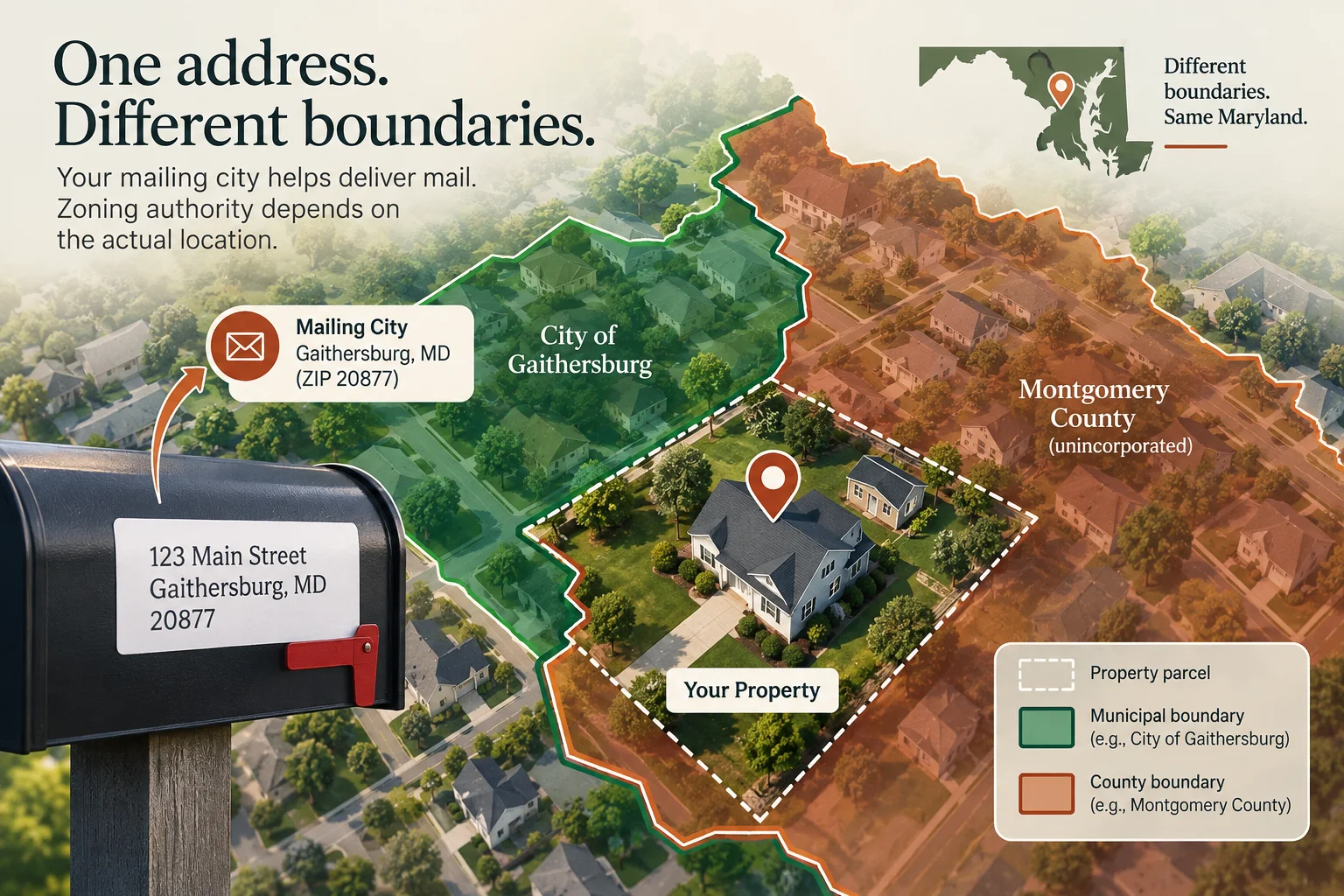
Postal addresses help deliver mail. They do not, by themselves, establish which government controls a property’s zoning. The finder uses the property’s coordinates and official boundary polygons, then checks a separate authority record.
Being inside a municipality does not always mean that municipality exercises zoning authority. Maryland’s planning framework treats local responsibilities separately. Read Maryland Planning’s explanation.
Near a municipal boundary or recently annexed? Ask the planning office to confirm the parcel. Maryland’s municipal GIS boundaries are planning data, not a legal property description.
A three-step check when your mailing city and map disagree
- Locate the actual parcel. Enter the street address above and check the suggested location. Keep the tax account or parcel identifier handy if the match is unclear.
- Check municipal boundaries, not ZIP-code shading. Gaithersburg’s official planning FAQ explains that postal delivery areas do not necessarily follow city boundaries. A Gaithersburg mailing address alone does not establish city jurisdiction.
- Confirm two responsibilities. Ask who controls zoning and who issues building permits for that parcel. If sources disagree or annexation is involved, request confirmation from the offices before selecting a local ADU rule.
Use parcel and assessment records to identify the property; ask the relevant offices to confirm the authority route. Once that route is clear, continue to the property feasibility checklist.
BEFORE YOU GO FURTHER
A few helpful answers.
Use this finder to establish where to start. Your parcel and ADU design need a separate review.
Back to address lookup ↑How should I enter my address?
Use the house number and street, plus the city or Maryland ZIP code. You can paste a multiline address block; the finder cleans common commas, spacing and country labels. Check any suggested match before continuing. A PO box, ZIP code alone or intersection is not a property address.
What if my address cannot be found?
Check the street number, spelling and ZIP code, then try again. New or unusual addresses may not yet match the state service. If no candidate is correct, use the County & City Rules Tracker and ask the planning office to identify your parcel. Do not select a nearby address as a substitute.
Does the result mean I can build an ADU?
No. The lookup identifies a planning route. It does not check your zoning district, allowable size, setbacks, utilities, overlays, easements or private restrictions. Continue with the Property Feasibility Checker to organize those questions.
What does “Needs verification” mean?
The address may be approximate or near a boundary, a boundary check may be unavailable, or an authority record may be incomplete. Read the reason beside the result. “Not yet verified” ADU status describes a research gap; it does not mean ADUs are prohibited.
What happens to my saved plan?
If you already have saved work, a lookup asks before changing it. For the same property, choose to keep your answers. For a different property, review and confirm the reset; a recovery copy is kept in this browser. Budget and bids are retained but must be reviewed for the new property. Your street address and coordinates are not stored in that saved profile. If browser storage is unavailable, the result will tell you.
What should I ask the planning office?
Ask: “Can you confirm the zoning authority and zoning district for this parcel? Which current ADU rules apply? Who handles zoning review and the building permit? Are there municipal, historic or other property-specific reviews I should check before commissioning plans?” Keep the matched address and parcel information handy.